| |
Coordinates: 55°01'55?N 1°33'21?W? / ?55.0318, -1.5557
Killingworth, formerly Killingworth Township, is a town north of Newcastle Upon Tyne, in North Tyneside, United Kingdom.
Built as a planned town in the 1960s, most of Killingworth's residents commute to Newcastle, or the city's surrounding area. However, Killingworth itself has a sizeable commercial centre, strong bus links to the rest of Tyne and Wear, several schools, a medical centre and library, which provide for the town's community. A new leisure centre which contains a 25 m swimming pool, gym and sauna opened in May 2007. Killingworth is not on the Tyne and Wear Metro network; .
Nearby towns/villages include Killingworth Village (which existed for centuries before the Township was built), Forest Hall, West Moor and Backworth.
[edit] Culture
- Killingworth was used in the filming of the sitcom Whatever Happened to the Likely Lads? in 1973/1974. The Highfields estate, built in the early 1970s and containing some of Killingworth's first privately-owned houses, was seen as a suitable location for the new home (on Agincourt) of the young couple Thelma and Bob, while Terry Collier works at a factory (filmed at the Killingworth industrial estate). Although Killingworth is not mentioned in the series, its presence can be seen as reflective of the times.
- In an episode of the architecture series Grundy's Wonders on Tyne Tees, John Grundy deemed Killingworth's former British Gas Research Centre [1] the best industrial building in the North East.
- Being at the edge of the original Town Moor, Killingworth has a lot of recreational land, such as the playing fields used by local schools and the Killingworth Arms Football Club. In 1996, several Newcastle United players, and the then-manager Kevin Keegan, opened a tarmacced football area in the west of Killingworth.
[edit] History of the Township
Construction of Killingworth, a new town, began in 1963. Intended for 20,000 people, it was a former mining community, and was formed on 760 acres (3.1 km²) of derelict colliery land near Killingworth Village, which had existed since the 18th century and earlier. The building of Killingworth Township was undertaken by Northumberland County Council, and was not sponsored by the Government. It was assigned "New Town" status in the 1960s in a similar fashion to the nearby town of Cramlington.
Unlike that town, Killingworth's planners adopted a radical approach to town centre design, resulting in a development of relatively high-rise buildings in an avant-garde and brutalist style, and won awards for architecture, dynamic industry and attractive environment.
This new town centre consisted of pre-cast concrete houses, 5- to 10-storey flats, office blocks and service buildings, shops, and car parks, interconnected by ramps and walkways. These made up a deck system of access to shopping and other facilities, constructed on the Swedish Skarne method of construction[2]. However, the walkways become dangerous and have since been demolished.
Killingworth in the early 1960s was originally called Killingworth Township, but after 40 years the Township was dropped and everyone calls it Killingworth or Killy.
Around 1964, during the reclamation of the derelict pit sites, a 15 acre lake south of the town centre was created; spoil heaps were levelled, seeded and planted with semi-mature trees. Today, swans, ducks and local wildlife live around the two lakes which span the main road into Killingworth. The lake is kept well stocked with fish and an angling club and model boating club use the lakes regularly.
|
|
Killingworth boating lake, 2 May 2006
|
Carriage formerly used to carry coal south of Killingworth.
|
[edit] Housing
[edit] Garths
Killingworth originally consisted of local authority houses. The first houses at Angus Close, owned by the local authority, were built to house key workers for the British Gas Research Center. The rest of Killingworth's estates were cul-de-sacs named "Garths" - all numbered, i.e. Garth One, Garth Two, Garth Three etc.
The houses in the Garths were built of concrete and had flat roofs, but around 1995 the Local Housing Association modernised the Garths in West Bailey (the west of Killingworth): they added pitched roofs to the flat-roofed homes, renewed fencing, built new brick sheds, and relocated roads and pathways. Along with this they changed several Garths' names and replaced them with names of lakes, birds and trees. The lowest remaining numbered Garth is Garth Four (the highest is Garth Thirty-Three in East Bailey).
Many of the Local Authority Homes have been purchased by the tenants, some of whom still reside in the houses that were built new in the 1960s.
[edit] Highfields, first privately-owned homes
Killingworth has grown since the early 1960s, with the addition of new privately-owned homes, Highfields Estate was built in the 1970s and was named after battles e.g. Flodden, Agincourt, Stamford, Culloden, etc.
[edit] Blocks of flats
The "Towers" (apartment blocks) were built in the 1970s. Tenanted by the local authority, they were made of dark grey concrete blocks, and were named Bamburgh Tower, Kielder Tower, etc. They had integrated walkways and alleys, but, not widely popular, they were demolished in the 1980s, and two new estates of privately-owned homes were built by Cussins Homes and Barratt Homes.
[edit] Town centre
[edit] History of commerce in Killingworth
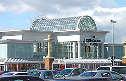
The Killingworth Centre, 2 May 2006
The first two shops built in Killingworth in the 1960s were Moore's and a small confectionery shop, situated between Garth Six and Angus Close and next door to the West House pub, but these shops were demolished in the 1970s.
The original town centre was built in the 1960s. The boxer Henry Cooper declared the shopping centre open while standing on the steps of the Puffing Billy pub. The centre included a large department store, Woolco, which sold groceries, car parts, and even incorporated a tyre service bay. The shopping centre also included Dewhurst butchers, Greggs bakery, and newsagents, but it was demolished in the 1980s.
In the 1980s and 1990s, the Morrisons shopping complex (containing the Morrisons supermarket) was the commercial centre of Killingworth, while the former Woolco site stood as wasteland for more than a decade. Then, in the early 2000s, the Killingworth Centre, a modern shopping mall, was built on the former Woolco site. It contains Morrisons (which relocated - its former building is now the Matalan clothing store), the Card Factory, Centre News newsagent, Trims For Him barber, Supercuts hairdresser, Thorntons chocolate shop, a chemist, Peacocks clothing store, Jobcentre Plus, Bowes Mitchell Estate Agents, Travel Agents, Wilkinsons, Deichmann shoe shop, Catalogue Bargain Shop, Peter's Bakery, an optician, Kodak photographic shop, bookmaker, DVD Hire/Sales, video games sales and McDonalds.
The Killingworth Centre also incorporates a covered bus station which is served by Stagecoach, Arriva, Go-North East, Northumbria Coaches and Classic Buses.
Raised above the car park is the Killingworth Health Centre which has a doctors' and dentists' surgery.
In December 2007 a planning application was submitted for a new KFC restaurant and a public house on the waste ground adjacent to the car park.
[edit] The White Swan Centre site

White Swan Centre, 8 May 2006
This is a large white building in the town centre.
Originally, a building owned by Merz & McLellan, built in the 1960s, stood here. This office block contained 100,000 square feet (10,000 m²) of office space and employed 600 professional and clerical people. Constructed by Northumberland County Council, the building towered over Killingworth and could be seen for miles around.
Over the years, the office space became vacant and, like the former Woolco site, it was disused through the 1990s. Then the building was reduced in height, remodernised, reopened and renamed the White Swan Centre. It incorporates the Killingworth Library, North Tyneside Council Rent and Rates Office, Education Centre, Coffee Shop,and Conference Rooms.
[edit] Schools
Killingworth is also home to three primary schools (Bailey Green, Moor Edge and Amberley) and a high school, George Stephenson High School. In recent years Killingworth moved from a three tier education system consiting of, First, Middle and High schools, to the current two tier system.
[edit] Public houses
Killingworth has two public houses (and there are two more in Killingworth Village).
- The West House, originally called the West House Inn, is in West Bailey. It was built from a derelict farmhouse and barn, in the style of an old Northumberland inn.
- The Station public house is on the industrial estate to the west of the town. It was originally next to the Killingworth railway station, which was demolished some years ago. The railway still runs by the Station pub, with a level crossing within 50 m of the pub.
- Killingworth Working Men's Social Club (in East Bailey) was built in the 1970s and located next to the Town Centre.
[edit] References
- , http://www.northtyneside.gov.uk/regeneration/docs/north%20west%20demographics.pdf
[edit] See also
Wikimedia Commons has media related to:
(Source: Wikipedia) |
|